Showing posts with label Kirk eddlemon. Show all posts

Friday, May 29, 2009

Exploring the Hidden Gorges of the Linville Wilderness

Out of all the places in the southeast that have been on the list to explore in a kayak, none have been as high priority as a small creek hidden from view, yet a stone's throw from one of the more popular mountain temples in the region. Linville Gorge is truly the standout locale in the area for west-esque grandeur and scale, and being protected and laced with outdoor opportunities, it is a mecca for climbers, kayakers, hikers, and fishermen. If you want to get "down in it" in the south, the 'Ville is the place to be immersed.

While hikers/grovellers have truly scoured the main gorge, and paddlers frequent the Linville River at the bottom, the east flanks of Table Rock and Hawksbill, which bring up the river left side of the gorge, have remained relatively untapped from a paddling perspective. While all the creeks to the east of NC181 have been thoroughly explored, Upper, Harper, Lost Cove, Gragg, and Wilson, the headwaters of Upper Steels Creek have been sitting right in the shadow of Table Rock all this time. A new world lies within the shadows here, in the way of two incredibly steep and impressive gorges.

We found out about this place the same way we have found out about most other remote pockets in North Carolina. Rich Stevenson's awesome website, http://www.ncwaterfalls.com/, is no secret around here, and is probably the number one tool I have used to locate many of the obscure places I have explored in the mountains of Western North Carolina. There is a picture on this site of the last falls in the lower gorge of Upper Steels Creek, and immediately upon seeing this update, we headed over shortly thereafter to scope the whole scene out.

When we hiked in one winter, what we found was a double scoop of some of the steepest and most fringe drops in the southeast. There are two gorges separated by a few hundred yards of flatwater. The first one was really awesome looking and seemed to be the more reasonable of the two. The second one is like a direct product of what would happen if Caveman on the Raven Fork and Landbridge on the Toxaway were to procreate. Both gorges are steep, with the first one dropping around 100 feet in a few hundred yards. But the second gorge, what we are referring to as "The Kamikaze" gorge, must drop that gradient in 100 yards. To take it in is quite overwhelming. If it wasn't runnable, the whole scene would be easier to swallow, but the runnability tempts your stomache with the nauseatingly compulsive emotions of "what if?" and "I got this".

Fast forward a few years to now. We had knocked off many of the explorations we had on the list, but Upper Steels had been knawing at us for years. It always ran on a weekday, it was always too far for the time we had, and on top of that, I had oversold it as such a scary place that volunteers were few and far between.

Finally, I had a day to burn, and though water levels had already peaked in the area, I suspected that due to the channellized nature of the creek, and the fact that everything else had been blown out the day before, we would be able to at least see it with some flow and get a better idea of what the feasibility of a full flow run would be. Keith Sprinkle was, is, and will always be in for some out of the box thinking and was more than interested in soaking in a new sense of place.

Keith, rock, water

I will say this. If the paddle in at the top is a good flow, ie what you normally would expect to have for a good paddle on a creek, stop. Get out of your boat and hike back to your car and go run the Gragg Prong! This run takes much less water than the other creeks that flow into Wilson Creek. Our paddle in was NOT encouraging. But as soon as we rounded the bend to the entrance of the first gorge, the cobbles disappeared, welcoming a fairyland of channelized granite.


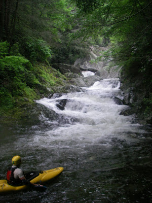
The first gorge starts with an awesome set of little teacups that then fan out onto a fun 20 foot slide with a nice kick at the bottom. The view from the top was perfection. It was the river bed of South Silver amidst the lush and humid setting of the high mountain southeast.


Teacups


Slide below Teacups

The yellow dot is Keith

After boofing and sliding down this sweet start, we ran another nice boof to slide and then got out at the big drop of the top gorge.

Nice boof to slide

The view was for sure epic. A tight, calm corridor led into a crack of 15 feet that then roared right into a stout bedrock series before disappearing around a twisting precarious turn.


Inspecting the crack rapid.

Beyond, all that could be seen was distant granite walls, and tree tops. With only two people, we skipped the crack and slid in carefully for the bedrock entrance to what was to be the highlight drop of our run that day.

Entrance to "The Beverly Hillbilly"

After speeding way too fast down the entrance into a microeddy at the lip, I took a deep breath and then paddled off of a 30-35 foot steep sliding drop that landed in a wall. The room from the landing to the wall was barely enough for a tight airplane turn upon impact, and it went just as I had dreamed it would for so many seasons. It feels so good to find something, plan it out, do the homework, wait for the timing, mobilize, assess, and pull the trigger.

Note to self, turn right at the intersection!

The drop was very similar to Wall Drug on Tatlow Creek, except you don't have to run it if you don't want to, and it may have been a little tighter.

Keith in the runout

After paddling down the lazy river hallway below the drop, we exited the first gorge and began banging down low water to the next pitch. We eddied out on the right and got out at the top of The Kamikaze Gorge. Keith's expression tells the whole story.

Epic.

There are two rapids in this gorge separated by a completely walled out giant pool. The first drop is a vision quest of moves and features, and is most certainly runnable. It starts with a 10 foot boof and a must make turn in the air to 8 foot clap. Then the bedrock rushes into the final tier, where the flow breaks right into the inside of the turn where potholes await. A crisp popping drive over the left brim will deliver the crazy person who is first to run this down a nice 20-25 foot slide into the halfway pool above the next huge drop, The Fringe.

Looking down, down, down, into Kamikaze Gorge


Entrance move

We are calling the next drop "The fringe" quite simply because it is. This drop didn't look good years ago at base flow, as it slides steeply and chaotically down into a wall, with no crossgrain options to remove one's self from harm. In the flow is the only place to go.

The Fringe from the base on river right

With even the small volume of water we had, this lower gorge was stout, with The Fringe building a nice cushiony boil on the wall, and a raised pool level. It goes! Sitting below this gorge is, along with sitting at the top of Windy Falls, and in between Landbridge and Wintergreen, the most epic of spots in this quadrant of the country.

The overwhelmingly impressive "Kamikaze Gorge" from the bottom

Stacked and jacked, this gorge needs to be paddled. But with dinner plans, being short staffed, and not feeling so "fringe", we took the Mountains to Sea trail around and then dropped to the base of The Fringe.

Below The Fringe, the creek still had one more long set of solid goodness. It starts right up with a nice series of stacked ledges amidst an intense backdrop.


Seems like he is always waving to the camera. Showoff.

Breathing it in

Then after a short pool there was a nice and fluffy 10-12 foot waterfall.


Keith at the base of the waterfall

This waterfall then led into a football field length slide in the wall kind of affair, with some interesting features at the bottom. We performed the volleyball net maneuver right above the last short stretch, which looked a little abusive, but the rest was "right proper" as some would put it.

Coming into the last tier

Raincheck

This butt crack of a canyon dropped us into an immeasurably deep pool, where we exited the hidden confines from above into the more open and typical nature of the lower.

This pool is at least 30-40 feet deep!

There was still one good long, blind slide that was fun, before the creek gentled to Wilson Creek type boogie to the takeout.

Looking back, this place is a must see for any paddler or hiker that doesn't mind a little bit of work for a seldom seen reward. The section we paddled was right up there with the more substantial places in North Carolina. Also, while we did walk the bottom stretch of insanity, it is certainly runnable, and considering people have run Garden of the Gods, this stretch is much more appealing, satisfying, and runnable for that matter. With a solid crew, unlimited time, and the right attitude, I am interested in going back and running the rest. Everything on the run is runnable, and if the whole thing was run top to bottom, I would say that it is maybe the hardest and most impressive creekboating in the southeast.

Mission accomplished, but there are still scraps left on this dinner table. Big, full course, where are the tums kinda scraps.

Can't wait to go back in!

Friday, April 17, 2009

The New Chattanooga Classic: Rock Creek


About a year ago, most Chattanooga boaters I talked to hadn't even heard of Rock Creek. If so, they were confusing it with the easy class 4 run up towards Dayton. But this is the Rock Creek that falls off of Lookout Mountain. A few guys knew of it and that it had been done, but other than that, there was nothing. Once again, another run that never got the full attention of boaters in Tennessee.

Access has been an issue since the run first started being picked off, as the land surrounding the creek is managed by the Lula Lake Land Trust. It hadn't been run in years, but while working in the area 2 years ago, I ventured into the canyon to find a beautiful and steep creek with many big rapids and drops. It was hard to tell how runnable it would be with flow, but from that moment on, I couldn't get Rock Creek out of my head.

About a year ago, it rained in Chattanooga around an inch or more. The Bear didn't come up, but Lookout Creek, which is the barometer for water conditions on the north side of the mountain, came up to 500 cfs. This was during a substantial drought, so a spike like that meant water was flowing on the surface and fast. Not being able to free anyone up for a run, I decided to go in solo, and take my time feeling out the place.

Since my first run, which was at a minimal flow, we sorted things out and came back a year later with medium-high flows. This level turned out to be even better, and I venture to say that 4-6 inches higher than this and every drop will be runnable. All of the pictures in this post are from the later high water trip.

There are two big drops at the top, the first one is around 25 feet and has a shallow landing, but can be run.


The second one is a 100 foot waterfall that is not good to go. The run starts below this big drop.


Puting in below the big drop is like riding the maid of the mist at Niagara. You can put your paddle in the air and sail across the pool from the downdraft. The run immediately kicks into 5th gear with the very first drop, which is one of the better rapids on the plateau. A double drop going into a low angle slide where a planing, hole punching turn is required halfway down before ducking under and through an undercut sliding corridor. The second drop of the double drop is an excellent 10 foot shoulder boof. What an awesome set.


Next is a section that will likely have some portages, but it could all be run with the right flows. First is a 15 foot jumble that is not runnable on the right, and dry on the left. You can wheelchair it, or do a slightly moving glorified seal launch. Next is a slot on the right where all the flow drives left into a horrible undercut. It currently has wood, making the line thinner than thin. The next drop is commonly run. The whole left side of the creek is no man's land, with sieves galore. Driving right through a crucial notch move puts you into a hanging eddy above a 15 foot drop that throws left onto a rock.


Driving right and dropping angle will yield a scary but tightly clean line. The next drop I ran the first time but no one ran the second. The creek runs down a broad low angle shelf and claps down a 15 foot waterfall, with the right and center being totally class 6. The only line is to drive hard left and further left still, being careful about not letting the clap throw you right into the center tombstone rock. The portage is on the right.

Then after a difficult boogie rapid you come to the steepest set on the run. Here is a sweet 10 foot sloper through a 2 foot wide slot in the middle of the creek.

This slot leads into the next and biggest drop on the run, Wet Dreams May Come. If you run it correctly, it is a no brainer, but if you somehow go down the right side, you will never be seen again, as this channel flows into the biggest sieve I have ever seen in person. Scraping down the left side to line it up safe is the way to go, and then all you lack is dropping 3 feet down a slab into the main drop, which is a 20-25 foot sliding waterfall that is just too much fun. A stout class 4 exit keeps you focused.


Below the big one, there is a nice garden leading into a bedrock ledge that you have to run right to left. You have to be real aggresive to avoid getting thrown right into a bad pin rock which has already seen some action just in the past month the creek has been seeing use.


Below here is a little portage that can be wheelchaired on the far left. After this, there are some nice ledges and boulder rapids before the final big one, Downward Spiral. This awesome ledge garden is almost like a spiral staircase winding clockwise from left to right.


It has 5 drops on it, with the first 2 being the more intense ones. This rapid is good ole fashioned boofing fun!

From here down the run calms, but not before a final slot that the creek channels into on the right. If it was 3 inches tighter no one would run it. But, as is, this slot is the perfect last drop. Below the last slot the run chills to class 3 and passes some nice homes on the left. Be quiet and move quickly, boofing a few dams and other drops. Then it is a mile paddle out down to Chattanooga Valley Road. Watch for a big logjam at the rail bridge.

Rock Creek is a great run. It has a solid half mile of class 5-5+, and some of the best scenery in the area. The rapids are similar to Morgan Creek, or a toned down Middle Creek. Moreover, the creek has a sizable watershed and is 10 minutes out of downtown Chattanooga. When the Bear is on the low to too low end, Rock will usually be at a perfect level.

The most important thing to remember about Rock Creek is that access is impermanent and delicate. For detailed info about access protocol, check http://www.waldensridgewhitewater.com/ . Here are some general guidelines:

The Land Trust is open the first and last Saturday of each month. DON'T run it on these days.

Don't run the 25 footer at the top, it is off limits.

Clean out trash in the gorge and pack it out if possible.

Don't be seen by ANYONE, other than fellow paddlers, in the gorge at all!

Be smart and considerate about shuttling, parking, and noise. Don't screw it up for everyone else.

Avoid leaving ANY cars on top of the mountain. Be low key.

The manager of the land who works for the trust is a really cool guy and wants us to be able to paddle in there. But it only takes a few assholes to ruin it for everyone. Follow the instructions on Waldens Ridge Whitewater for access. This involves notifying the caretaker a day or days in advance, filling out a waiver, and following all rules.

This ain't Suck Creek, in any way shape or form. Serious skills and a covert mindset are both mandatory. Enjoy the run for now.

Wednesday, October 29, 2008

Linville Rendezvous

Drought conditions are pretty hard on whitewater paddlers in the southeast these days. That being said, there is one run that still seems to run at least one day a month. Linville has run 7 days in the past 2 and a half months. Having got back from BC, I had some serious catching up to do at home and had not been able to get on it the times it came up.

But, having allocated some time to go to the Russell Fork for the race, I knew as usual something would come along that would interfere with my Russell Fork plans. Luckily, for the last few years, that obstacle always seems to end up being a few inches of rain in the high country, resulting in cush flows for Linville.

Linville is the best river run in the eastern part of the continent. I haven't paddled every river in this region, but I am sure it beats anything else. Not many people run it for some reason, and I attribute that in part to the misinformation passed around the paddling community about what kind of flows are required for a good run. The gauge changed in 2004 after the floods, but there is much dispute now about whether or not it may be settling out. I KNOW it is settling out back to previous flow correlations, and is only around 0.2 feet off of pre-flood levels. Anyway, let the video be the judge. We had what many North Carolinians refer to as "minimum for sure". You can decide if it might be scrapable lower than our flow.

So here is a short video of our day on Linville on Saturday. It ended up being the best day I have had out there. The water was solid, and the leaves were amazing. We had two first timers too, and they now have a new favorite.


Linville Gorge from Kirk Eddlemon on Vimeo.

Props to Keith to stepping up to the run without a drytop and much of anything. Nick's vinatage pink shorty splash top loaner was classic. No wonder some of the footage was so shaky.

Monday, September 29, 2008

The end of a journey: Goodbye BC

After an epic and wondrous experience on Tatlow Creek, we lingered at the takeout in hopes that the rain would hold off and we could get another run the next morning before heading home. Unfortunately, it rained all night and we woke up to a creek on the rise, and figured it would be too high by the time we got to the top. Disappointed, we packed up and headed downstream, hoping the mine would not have responded yet. Alas, the tributaries had all risen substantially, and with it still raining hard and the Ashlu running really high, we abandoned the idea of running a cranking mine run with no guide.

We rolled out of the Ashlu Valley, intent on returning, and Bryan Smith suggested that some of the coast huck stops might have some flow from all the rain. We checked Brittania Creek and found a low but doable flow for the double 20 at the bridge. Everyone else had little interest, but I would never pass something that clean and quality up back home, so I rolled the wet gear on and warmed up before dropping right into the set.

The first one is really only 15 feet, but the second one felt like a little more than twenty. It is a great drop and a good cap to our travels in BC. Fitting that it should end with a few clean waterfalls.


The drive along the coast on Hwy 99 was beautiful and the usual feelings of sadness that it was over, but also anxiousness to get home dominated the rest of the day. We spent 3 hours at the border, as this time we elected to cross at an interstate checkpoint. After finally rolling into Seattle and grabbing a room, we took a soak in the warmest water of the trip, the hotel hot tub. A few winks and 2000 miles later, we were back in Tennessee, and the trip was over.

I will never forget British Columbia. It has the best whitewater, most beautiful environments, and most intense and enjoyable gorges of anywhere I have ever paddled. It is hard to not want to just go back next year, but the call of the new and unknown is distant but clear. Everyone signed a roll call for Middle Kings at the bar in Nashville, but I don't think I can swing the time next year. Who knows where we will go, but I can tell you a few things. It won't have a road next to it, there will be overnight gear, there may or may not be a long hike in, and there WILL be waterfalls.

Till next time,