
Out of all the places in the southeast that have been on the list to explore in a kayak, none have been as high priority as a small creek hidden from view, yet a stone's throw from one of the more popular mountain temples in the region. Linville Gorge is truly the standout locale in the area for west-esque grandeur and scale, and being protected and laced with outdoor opportunities, it is a mecca for climbers, kayakers, hikers, and fishermen. If you want to get "down in it" in the south, the 'Ville is the place to be immersed.
While hikers/grovellers have truly scoured the main gorge, and paddlers frequent the Linville River at the bottom, the east flanks of Table Rock and Hawksbill, which bring up the river left side of the gorge, have remained relatively untapped from a paddling perspective. While all the creeks to the east of NC181 have been thoroughly explored, Upper, Harper, Lost Cove, Gragg, and Wilson, the headwaters of Upper Steels Creek have been sitting right in the shadow of Table Rock all this time. A new world lies within the shadows here, in the way of two incredibly steep and impressive gorges.
We found out about this place the same way we have found out about most other remote pockets in North Carolina. Rich Stevenson's awesome website, http://www.ncwaterfalls.com/, is no secret around here, and is probably the number one tool I have used to locate many of the obscure places I have explored in the mountains of Western North Carolina. There is a picture on this site of the last falls in the lower gorge of Upper Steels Creek, and immediately upon seeing this update, we headed over shortly thereafter to scope the whole scene out.
When we hiked in one winter, what we found was a double scoop of some of the steepest and most fringe drops in the southeast. There are two gorges separated by a few hundred yards of flatwater. The first one was really awesome looking and seemed to be the more reasonable of the two. The second one is like a direct product of what would happen if Caveman on the Raven Fork and Landbridge on the Toxaway were to procreate. Both gorges are steep, with the first one dropping around 100 feet in a few hundred yards. But the second gorge, what we are referring to as "The Kamikaze" gorge, must drop that gradient in 100 yards. To take it in is quite overwhelming. If it wasn't runnable, the whole scene would be easier to swallow, but the runnability tempts your stomache with the nauseatingly compulsive emotions of "what if?" and "I got this".
Fast forward a few years to now. We had knocked off many of the explorations we had on the list, but Upper Steels had been knawing at us for years. It always ran on a weekday, it was always too far for the time we had, and on top of that, I had oversold it as such a scary place that volunteers were few and far between.
Finally, I had a day to burn, and though water levels had already peaked in the area, I suspected that due to the channellized nature of the creek, and the fact that everything else had been blown out the day before, we would be able to at least see it with some flow and get a better idea of what the feasibility of a full flow run would be. Keith Sprinkle was, is, and will always be in for some out of the box thinking and was more than interested in soaking in a new sense of place.
Keith, rock, water
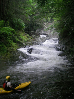
I will say this. If the paddle in at the top is a good flow, ie what you normally would expect to have for a good paddle on a creek, stop. Get out of your boat and hike back to your car and go run the Gragg Prong! This run takes much less water than the other creeks that flow into Wilson Creek. Our paddle in was NOT encouraging. But as soon as we rounded the bend to the entrance of the first gorge, the cobbles disappeared, welcoming a fairyland of channelized granite.
The first gorge starts with an awesome set of little teacups that then fan out onto a fun 20 foot slide with a nice kick at the bottom. The view from the top was perfection. It was the river bed of South Silver amidst the lush and humid setting of the high mountain southeast.
Teacups
Slide below Teacups
The yellow dot is Keith
After boofing and sliding down this sweet start, we ran another nice boof to slide and then got out at the big drop of the top gorge.
Nice boof to slide
The view was for sure epic. A tight, calm corridor led into a crack of 15 feet that then roared right into a stout bedrock series before disappearing around a twisting precarious turn.
Inspecting the crack rapid.
Beyond, all that could be seen was distant granite walls, and tree tops. With only two people, we skipped the crack and slid in carefully for the bedrock entrance to what was to be the highlight drop of our run that day.
Entrance to "The Beverly Hillbilly"
After speeding way too fast down the entrance into a microeddy at the lip, I took a deep breath and then paddled off of a 30-35 foot steep sliding drop that landed in a wall. The room from the landing to the wall was barely enough for a tight airplane turn upon impact, and it went just as I had dreamed it would for so many seasons. It feels so good to find something, plan it out, do the homework, wait for the timing, mobilize, assess, and pull the trigger.
Note to self, turn right at the intersection!
The drop was very similar to Wall Drug on Tatlow Creek, except you don't have to run it if you don't want to, and it may have been a little tighter.

Keith in the runout
After paddling down the lazy river hallway below the drop, we exited the first gorge and began banging down low water to the next pitch. We eddied out on the right and got out at the top of The Kamikaze Gorge. Keith's expression tells the whole story.
 Epic.
Epic.
There are two rapids in this gorge separated by a completely walled out giant pool. The first drop is a vision quest of moves and features, and is most certainly runnable. It starts with a 10 foot boof and a must make turn in the air to 8 foot clap. Then the bedrock rushes into the final tier, where the flow breaks right into the inside of the turn where potholes await. A crisp popping drive over the left brim will deliver the crazy person who is first to run this down a nice 20-25 foot slide into the halfway pool above the next huge drop, The Fringe.

Looking down, down, down, into Kamikaze Gorge

Entrance move
We are calling the next drop "The fringe" quite simply because it is. This drop didn't look good years ago at base flow, as it slides steeply and chaotically down into a wall, with no crossgrain options to remove one's self from harm. In the flow is the only place to go.

The Fringe from the base on river right
With even the small volume of water we had, this lower gorge was stout, with The Fringe building a nice cushiony boil on the wall, and a raised pool level. It goes! Sitting below this gorge is, along with sitting at the top of Windy Falls, and in between Landbridge and Wintergreen, the most epic of spots in this quadrant of the country.

The overwhelmingly impressive "Kamikaze Gorge" from the bottom
Stacked and jacked, this gorge needs to be paddled. But with dinner plans, being short staffed, and not feeling so "fringe", we took the Mountains to Sea trail around and then dropped to the base of The Fringe.
Below The Fringe, the creek still had one more long set of solid goodness. It starts right up with a nice series of stacked ledges amidst an intense backdrop.


Seems like he is always waving to the camera. Showoff.
Breathing it in
Then after a short pool there was a nice and fluffy 10-12 foot waterfall.


Keith at the base of the waterfall
This waterfall then led into a football field length slide in the wall kind of affair, with some interesting features at the bottom. We performed the volleyball net maneuver right above the last short stretch, which looked a little abusive, but the rest was "right proper" as some would put it.

Coming into the last tier

Raincheck
This butt crack of a canyon dropped us into an immeasurably deep pool, where we exited the hidden confines from above into the more open and typical nature of the lower.

This pool is at least 30-40 feet deep!
There was still one good long, blind slide that was fun, before the creek gentled to Wilson Creek type boogie to the takeout.
Looking back, this place is a must see for any paddler or hiker that doesn't mind a little bit of work for a seldom seen reward. The section we paddled was right up there with the more substantial places in North Carolina. Also, while we did walk the bottom stretch of insanity, it is certainly runnable, and considering people have run Garden of the Gods, this stretch is much more appealing, satisfying, and runnable for that matter. With a solid crew, unlimited time, and the right attitude, I am interested in going back and running the rest. Everything on the run is runnable, and if the whole thing was run top to bottom, I would say that it is maybe the hardest and most impressive creekboating in the southeast.
Mission accomplished, but there are still scraps left on this dinner table. Big, full course, where are the tums kinda scraps.
Can't wait to go back in!


2 comments:
That's crazy! I really appreciate the kind comments about my web site. Is all that up Steels Creek from where I posted my pictures from?? I'm getting my maps out now...
Rich Stevenson
ncwaterfalls.com
sorry kirk, but there was raft descent already done some time ago:
http://www.pbase.com/waterfallrich/image/64657525
Post a Comment